
Phenology Invasive Species
Tulip Gardens
GPS
Phenology Exercises: Finding a Field Site
Steps to Establishing a Phenology Field Site
The key to a good field site is finding an area that can be used for multiple purposes, such as phenology
observations, invasive species observations, and possibly even establishing a picture post. A good site would
be located in an area of native vegetation in a natural state, that is, not watered or fertilized. Any site
can be used as a field site, as long as it is adequately described with regards to geographic coordinates,
photographs and sketch maps. You should also keep in mind that good observations will come from areas with
minimal human disturbance.
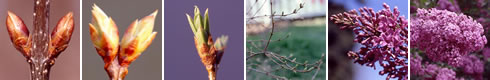
1. Assess plant species available for monitoring
Some common species include:
- Trembling Aspen
- Plains Cottonwood
- Balsam Cottonwood
- Common Lilac
- Ponderosa Pine
- Douglas Fir
- Forsythia
- Common Dandelion
- Canada Thistle
- Colorado Blue Columbine
- American Linden
2. Choose a site that is easily accessible for monitoring, and be sure that you have permission to access it if it is not on school grounds
3. If you would like to monitor invasive plants at your site
- Select species that you want to observe and record their current level of invasion
- Look for a site with varying topography, sun/shade, and water
- If your area is already invaded, it would be a good place to assess the effectiveness of various treatments for invasive species and to evaluate the spread or reduction in the invasion
- You may also record your findings with the Citizen Science (CitSci) website
4. Get the GPS coordinates of your site
5. Record any additional information about the site, including city, state, street location, location relative to the school, etc. Add this additional information to your sketch of the site map
6. If you are planning to establish a Picture Post at your site, ensure that you have permission to install it
7. Describe the site in as much detail as possible, including:
- Plant species list
- Geographic coordinates
- Type of landscape (vegetated, garden, landscaped...)
- Note whether the area is fertilized or watered
9. Draw a sketch map of the site
10. Keep this information in a safe and accessible place for future monitoring
This field procedure is also available in a printable handout form here.
Image Source: Project BudBurst